Simulated atomic bombs became widely known in Japan in 1991, following research into U.S. military documents by a citizens’ group in Kasugai, Aichi Prefecture, dedicated to recording the city’s wartime history. Forty-six years had passed since the attacks. In the affected areas, people knew that a single B-29 had dropped a large bomb, but it was commonly assumed to have been a one-ton bomb.
U.S. records also showed that a simulated atomic bomb had been aimed at Otsu in Kitaibaraki. Members of the Kasugai group reportedly visited Otsu in 1992 to interview residents. They found no clues, and the location was recorded as unknown, with the possibility that the bomb had fallen into the sea.
Around 2010, Professor Sumio Ito of the University of Tsukuba, who was compiling research on wartime sites in Ibaraki Prefecture, conducted interviews in Otsu with the help of Kitaibaraki local historian Kenichi Tan. Again, no decisive testimony appears to have emerged, and a sea impact was suggested. This work was reported in the Asahi Shimbun on July 20, 2010, in an article seeking memories of atomic bomb training.
Tan later asked residents in the Kamioka district of Sekinami about the event. He heard about a large bomb falling at “Bomb Hill” and realized that this might be the simulated atomic bomb site. Perhaps because there was no route from Kamioka to the hill, he was told—incorrectly, as it turned out—that it was in the Usuba district of Hanakawa. He went from house to house in Usuba. Someone suggested that a particular pond embankment might mark the bomb crater, but the precise location of Bomb Hill remained unknown.
Around the same time, the late Katsutoshi Suzuki, a former principal of Isohara Junior High School, visited Yamakoshi, an area known for ornamental carp, and stopped at the Nagaoka War Damage Museum. There he learned about the simulated atomic bomb dropped on Nagaoka, and was told that one had also been dropped on Kitaibaraki on July 20. He later said that he had felt deeply embarrassed that people in Nagaoka knew more about this part of Kitaibaraki’s history than he did. He visited the Nagaoka impact-site monument and brought home a booklet called The Bomb at Sakon.
When Katsutoshi told his elder brother Kazuo Suzuki about the Otsu bomb, they realized that its date and time matched a bombing Kazuo had experienced in Isohara at the age of 15. Late on July 19, 1945, B-29s flying north after the Hitachi raid had attacked central Isohara with incendiaries. The Suzuki family home took a direct hit and burned down. Kazuo clearly remembered that at about 8 a.m. the next morning, a single B-29 approached from the northwest and dropped a bomb. It was cloudy, with intermittent light rain, and he could not see the aircraft. In his written account he recorded hearing the approaching B-29, hearing the bomb fall, hurrying into the shelter of trees, and experiencing the extraordinary sound and vibration of the explosion. Remarkably, Katsutoshi was born the following day, July 21.
At the time, Kazuo learned that the bomb had fallen in hills near the area that would become the Dainippon district, developed as housing for the Dainippon coal mine. He did not know its exact impact point.
Residents of old Isohara and neighboring areas had in fact long called these hills “Bomb Hill,” because a large bomb had fallen there shortly before the end of the war. For years, however, people said that a one-ton bomb had been discarded in the hills. No one imagined that it had been a 4.8-ton simulated atomic bomb.
In 2018, plans began for a large Kitaibaraki solar power plant near Bomb Hill, to be developed by the Japanese subsidiary of the German company BayWa. On May 18, 2018, a chain of coincidences brought news of this project to Katsutoshi through my mother, Kaoru Noguchi. Hearing of Bomb Hill for the first time, he had an insight: could the bomb that fell there have been Kitaibaraki’s simulated atomic bomb? Katsutoshi Suzuki’s realization on May 18, 2018, was the starting point for identifying the site.
My father, the late Tomoo Noguchi, had witnessed the bomb fall when he was four years and eleven months old. Katsutoshi visited our home repeatedly to interview him and became increasingly convinced that Bomb Hill was the impact site.
On June 23, 2018, Katsutoshi attended a symposium on passing on the history of wartime remains and building communities committed to peace, organized by the prefectural local-government research institute. He attended with Abe (安部憲夫), whom he knew through the Noguchi Ujo association. After a presentation by Kenichi Tan on Kitaibaraki’s wartime remains, Katsutoshi described the sequence of discoveries during the question-and-answer session. Katsutoshi, Abe, Tan and Asahi Shimbun reporter Komatsu (小松重則) then tried to investigate the site before construction of the solar power plant. But the access route had been neglected for so long that they could not get close. Sadly, Katsutoshi subsequently became ill and died in June 2019.
After Katsutoshi’s death, Tan took the lead in the investigation. Tomoo learned from Ishikawa (石川満) that the rice field where the bomb had fallen had belonged to the Kanazawa family. Tomoo passed this on to Tan, who later interviewed Shozo Kanazawa. Although born after the war, Shozo had often heard from his father and others about a large bomb falling in their rice field shortly before the war ended. He confirmed that the impact had left a large depression that could no longer be cultivated. The land parcel containing the impact site was also identified.
Unfortunately, by the time the parcel number was established, grading of the land for the solar power plant had begun, making it difficult to search for physical traces. A detailed on-site investigation and preservation of the site could not be carried out before the land was leveled.
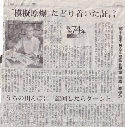
Tan compiled the findings and passed them to Komatsu of the Asahi Shimbun’s Hitachi bureau. Komatsu interviewed Tomoo Noguchi and Shozo Kanazawa again. The resulting article, published in the Ibaraki edition on September 20, 2019, traced testimony suggesting that the simulated atomic bomb had fallen in Isohara, Kitaibaraki. This was the first public report identifying the rice field at Irioosawa in Isohara—the area known as Bomb Hill—as the likely impact site.
In September 2020, I, Tomonori Noguchi, used the Geospatial Information Authority of Japan’s map and aerial photograph service and found what appeared to be a bomb crater in a U.S. aerial photograph taken on June 8, 1946 (U159A-5_CA_0048). I emailed Yozo Kudo, a leading researcher of air raids using U.S. military records who was investigating the coordinates of simulated atomic bomb sites. He replied that the feature had the characteristics of such an impact and was highly likely to be a crater remnant. By overlaying the aerial photograph on a modern map, he calculated the location as 36°48′54″N, 140°44′40″E.
The apparent crater in the aerial photograph provided strong evidence and enabled an estimate of the impact coordinates. On December 19, 2020, I presented the discovery online at a study meeting on researching and using U.S. military records, organized by the national liaison council of groups recording air raids and war damage.
After this presentation, Professor Ito advised me to collect more testimony. We decided to appeal for memories through Kitaibaraki’s municipal newsletter. Mamoru Noguchi, a former landowner at the solar power site, offered the same advice. I opened this page in January 2021 as a contact point for collecting those accounts.
The image is the September 20, 2019, Ibaraki morning edition of the Asahi Shimbun, which first publicly identified Irioosawa in Isohara as the possible impact site. The image resolution has been reduced to keep its reproduction within the intended scope of quotation.
Select the image to view it in a new tab.